Find my route
De Marche-en-Famenne à Erezée
On the Line 43 RAVeL (Marche - Hotton) and the Line 620 pre-RAVeL (Hotton - Erezée)

Medium
")
18,5 km
Starting from Marche, capital of the Famenne region and a favourite spot for cyclists with 350 km of waymarked roads dedicated to bikes, you first follow the RAVeL and a connecting cycle path that takes you to Hotton.
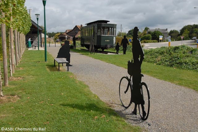
Hotton, a small town with undeniable tourist attractions, through which the Ourthe river flows quietly, will delight you with its architectural heritage typical of the Ardennes. Your trip continues through fields and groves to end in Erezée, which stands on a ridge overlooking the Aisne and Estinale valleys, where you can go back in time on board the tourist tramway.
Details
The route:
The route largely follows its own path on the RAVeL and on quiet roads.
To cross through Hotton when you leave the RAVeL, turn right into rue de Famenne, then left into rue Emile Parfrony and follow the signs to the centre of Hotton.
Cross the bridge over the Ourthe. Immediately after the bridge, turn right into rue Haute as far as the roundabout. Take the second exit, where you can join the RAVeL again at the end of rue Haie-Notre Dame.
Surface:
Between Marche, Hotton and Ny, smooth asphalt surface. After Ny, partly uneven surface (fine compacted stones).
Height difference:
Imperceptible incline, ascent of 167 metres.
Signs:
Full directional signs between Marche and Hotton. Partial signs between Hotton and Erezée. To organise your trip as well as possible, you can refer to the RAVeL map of the Province of Luxembourg or download the GPX file below. You can also follow nodal points 22, 19, 17, 70, 73, 74 and 76 of the Pays de Famenne region by bike.
Safety, precautions:
You cross through Hotton along quiet shared roads, but the caution is recommended.
Warnings
Useful info
Starting point:
Start of the RAVeL at the parking area of the Cultural and Sports Center of Marche-en-Famenne, Chaussée de l'Ourthe 74.
Coordinates Lambert 72 : X : 220020 m - Y : 102750 m
GPS coordinates: Latitude: 50°13'53.96" N- Longitude: 5°21'0.59" E
Access by Train: Marche-en-Famenne SNCB railway station.
Arrival point :
At the end of the RAVeL, rue du Pont d'Erezée.
Coordinates Lambert 72 : X : 234013 m - Y : 109347 m
GPS coordinates: Latitude: 50°17'20.86" N - Longitude: 5°32'51.85" E
Rest areas:
Hotton (right bank of the Ourthe), La Roche-en-Ardenne centre.
Guides/maps:
- RAVeL map of the Province of Luxembourg published by the SPW. This map, called ‘More RAVeL, more pleasure’, can be ordered free of charge via the RAVeL website by clicking here.
- Map of the Pays de Famenne region by bike (nodal points), distributed by the Tourist Offices.
Around the route by bike:
Stage map