Find my route
De Libramont à Bouillon (stage 5)
On the minor roads of the Ardennes

Medium
")
37 km
Along this final stage you leave Libramont, a small provincial town where life is good, to unwind in the heart of the Ardennes. Quaint villages with old shale and sandstone farms are dotted all along the way and from time to time, the smell of salted foods and Ardennes game will make your mouth water.
As you go through Offagne and Fays-les-Veneurs, you enter Paliseul, a haven of peace renowned for its local products, which invites you to make a gourmet stop.
The route becomes ever more mysterious. Nollevaux, Bellevaux and Noirefontaine herald your imminent arrival in the sumptuous Semois valley. The almost mountainous massif on the approach to Bouillon is sure to provide you with a change of scenery.
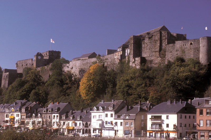
Suddenly, you plunge down towards the valley and before you appears the 10th-century feudal castle, the jewel of the old ducal city of Bouillon. This brings you to the end of this fantastic ride.
Details
The route:
The route runs mainly along quiet minor roads, away from motor traffic.
Surface:
Smooth (mostly asphalt).
Height difference:
Hilly route, but no great difficulty. Steep descent into Bouillon.
Signs:
Specific W7 directional signs are in place along the entire route.
Connections:
In Bouillon, connection with Regional Route W7 towards Corbion, or Sedan (F) (connecting with EuroVelo 19 - Meuse à vélo).
Warnings
Useful info
Start:
Place communale de Libramont, near the Halle aux Foires.
Coordinates Lambert 72 : X : 222467 m - Y : 67634 m
GPS coordinates: Latitude: 49°54'56.43 "N - Longitude: 5°22'39.95 "E
Access by Train: Libramont SNCB railway station.
Access by car: Easy parking near the start.
Guides/maps:
- RAVeL map of the Province of Luxembourg published by the SPW. This map, called ‘More RAVeL, more pleasure’ can be ordered free of charge by clicking here.
Stage map