Find my route
De Sankt-Vith/Saint-Vith à Gouvy (stage 3)
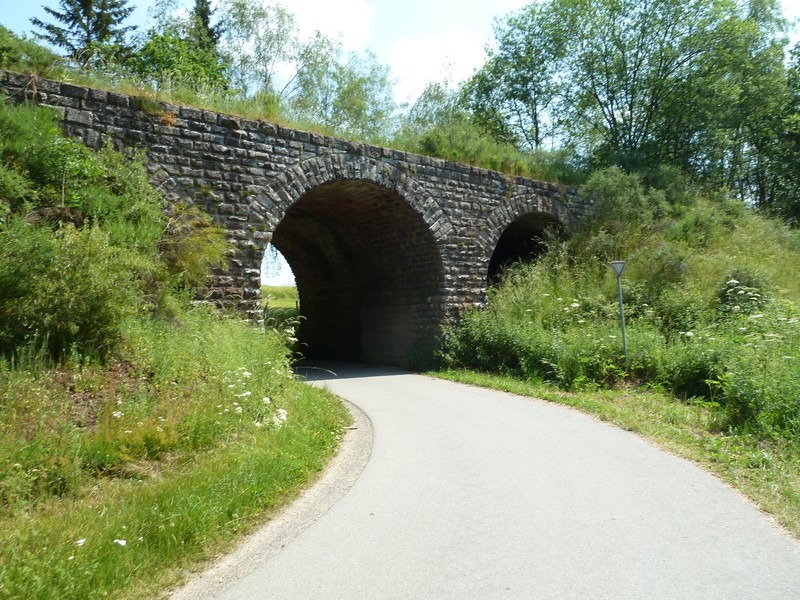
On the Line 47 RAVeL and the connecting cycle path to Line 163

Family
")
32,5 km
Starting in Saint-Vith/Sankt-Vith, a commune that has been tossed from one side of the border to the other by the vagaries of history, this stage takes you towards the romantic Our valley, nestling among the massifs of the Eifel and the Ardennes. Heading towards Hemmeres, you again cross the Belgian-German border.
Returning to Belgium via the village of Auel, in the distance you will soon see the ruins of the Burg-Reuland fortress, the high point of this stage, which has overlooked the region since the 12th century.
You then go along the river Ulf towards the Grand Duchy of Luxembourg where, shortly after Lengeler, an undeveloped tunnel marks the border. The tunnel is unfortunately inaccessible as a rare species of bat has made its home in this obscure passage into Luxembourg and now has protected status. Nevertheless, equipment and educational information about the life of the bats encourage you to head towards this enigmatic spot.
As soon as you arrive in Luxembourg, you leave the Vennbahn towards Huldange and a connecting route takes you to Gouvy, where legends are part of the local folklore.
Details
The route:
From the site of the old Saint-Vith railway station, you follow the Vennbahn (Line 147 RAVeL from Saint-Vith) for 800 metres, then you are directed left on minor roads as far as Neidingen. Take care not to miss a panel at each crossroads.
When you leave Neidingen, take the old line again, go through a tunnel and across the site of the old Lommersweiler railway station. As you leave, bear sharp right along minor roads towards Hemmeres (D). In this village, go to the right along the old line again, the continuation of the Line 47 RAVeL. You return to Belgium across a wooden bridge and then head towards Auel, Reuland, Oudler and Lengeler.
After the site of the old Lengeler railway station, at a small crossroads, the RAVeL continues for just over a kilometre. However, it leads to a tunnel that is inaccessible as protected bats live there. To carry on towards Gouvy, you are directed left along a concreted farm track with gradient of 6-10% for just over one kilometre. You enter the Grand Duchy of Luxembourg. You go through a tunnel underneath a main road. Just after the tunnel, you come to a crossroads. Troisvierges (L) lies straight ahead (continuation of the Vennbahn), BUT to follow the W9 route, turn right towards Huldange referring to the detailed description of ‘Stage 3 towards Gouvy’ which you can download by clicking here. Follow the signs to Gouvy-Bastogne. Take care to check the signs at each crossroads. Some of them may be hidden by the vegetation.
You go through Huldange and Hautbellain (spelled Haut-Bellain in Belgium), cross the Belgian border in the middle of fields and reach a site on the edge of a wood with a parking area and information panels. You are in the place called ‘Haie de Bellain’.
Gouvy is signposted on the right, 2.2 kilometres away.
The W9 route continues on the left to Bastogne (Line 163 RAVeL, see stage 4).
Surface:
Smooth, asphalt.
Height difference:
On the Vennbahn RAVeL, the downhill then uphill slopes do not exceed a gradient of 1.5%. After Lengeler, steep climb for about one kilometre, followed by a series of moderate uphill and downhill stretches.
Signs:
Full directional signs are in place.
Safety, precautions:
Take care when crossing roads.
Connections (the kilometres are counted from the starting point in Saint-Vith)
- Just after Lommersweiler, connection with the Eifel-Ardennen-Radweg cycling route to Prüm (D). As far as the border at Steinebrück, this is the Line 46 RAVeL.
- As indicated above, in the Grand Duchy, just after you go through a tunnel under a main road, you come to a crossroads where the W9 route turns right. The Vennbahn, meanwhile, continues straight on towards Troisvierges via the PC (national cycle path) 21.
Warnings
Useful info
Start:
Saint-Vith, Triangel cultural centre (site of the old railway station), Vennbahnstraße 2, B-4780 Saint-Vith.
Coordinates Lambert 72 : X : 275463 m - Y : 109230 m
GPS coordinates: Latitude: 50°16'51'' N - Longitude: 06°07'45'' E
Access by car: From the town centre, go down Mühlenbachstraße then turn right into Bahnhofstraße at the Triangel centre. First follow the signs to Prüm and Troisvierges with the Vennbahn logo.
Finish:
Gouvy, the place called ‘Haie de Bellain’, rue du Wago. Parking area, end of the Line 163 RAVeL to Bastogne.
Coordinates Lambert 72 : X : 263640 m - Y : 96799 m
GPS coordinates: Latitude: 50° 10' 17'' N - Longitude: 05° 57' 35'' E
To go to the centre of the town upon arriving: follow the directional signs marked Gouvy.
To return or continue by train: Belgian railway station in Gouvy (2.2 km from the route), on the Liège-Luxembourg line, which goes among others to Troisvierges station, at the southern end of the Vennbahn, and of course Liège.
Rest areas:
Lommersweiler, Haie de Bellain (end of stage in Gouvy).
Guides/maps:
- RAVeL map of the Province of Liège published by the SPW. This map, called ‘More RAVeL, more pleasure’, can be ordered free of charge by clicking here.
- All documentation can be obtained via the ATEB website (http://www.eastbelgium.com/fr/). In particular, a map to a scale of 1/100,000 is available which gives details of the path followed by the Vennbahn and indicates the connections with other RAVeL routes as well as other connections to the German cycling route and greenways network (Radweg).
Around the route by bike:
- VeloTour – Hautes Fagnes – Eifel nodal-points cycling route network: https://www.ostbelgien.eu/fr
- A number of loops use part of the route. These loops are included in a box set called ‘Vennbahn Plus’ which contains an illustrated map of the Vennbahn and a leaflet for each loop with a detailed map and tourist information. See https://www.ostbelgien.eu/fr
Stage map