Find my route
De Roubaix (F) à Renaix/Ronse (stage 1)
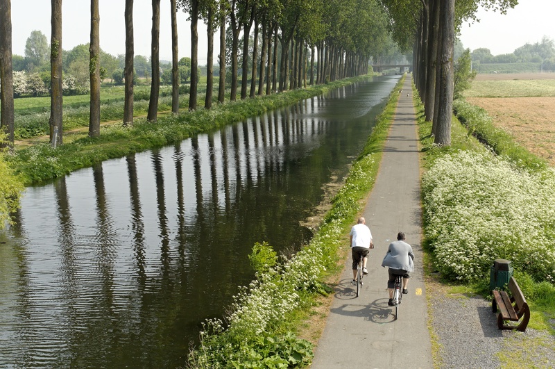
On the RAVeL of the Espierres canal, the Scheldt and Line 83

Family
")
32,5 km
Having left Lille, the capital of French Flanders, you follow the greenway along the Roubaix canal, which becomes the Espierres canal RAVeL when you enter Wallonia at the Leers-Nord lock (Estaimpuis). Here you can enjoy refreshments at the Maison du Canal coffee shop. This quiet café in an old lock house offers a range of regional beers.
As you make your way along the Espierres canal, you can immerse yourself in the past of the inland waterways in this lovely region with its small locks and drawbridges that will send your imagination sailing along with the lapping water. This canal, which fell into disuse in 1985, was recognised as part of Walloon heritage in the year 2000. The pastoral, restful atmosphere in this magical place will make you want to slow down and enjoy the moment.
When you reach Espierres-Helchin/Spiere-Helkijn, you join the left bank of the Scheldt in Flanders. Here you can’t help but notice that the peace and quiet of a preserved canal is at an end and the waterway traffic becomes heavier. Following the course of the river, you wind back and forth between Flanders and Wallonia. Shortly after Escanaffles you will see in front of you the magnificent cycle-footbridge known as the Pont de chemin de fer over the old No 83 railway line which once linked Avelgem to Renaix/Ronse and has now been partly converted into a greenway. You cross the Scheldt and go into Wallonia, leaving the water’s edge for good as you enter the Pays des Collines nature reserve. You cross the rural commune of Mont-de-l’Enclus, where the landscapes attract many hikers. Finally, you arrive in Renaix/Ronse, the pearl of the Flemish Ardennes and the end of this stage. Here you will find many places where you can enjoy refreshments and obtain services.
Details
The route:
The route runs largely along the RAVeL of the Espierres Canal, the Scheldt and Line 83 in Wallonia. Here and there, it also follows quiet roads.
Surface:
Smooth - alternately asphalt and concrete.
Height difference:
Flat or imperceptible incline.
Signs:
Only the section in Wallonia along the Espierres canal, on the Line 83 RAVeL and through the commune of Mont-de-l'Enclus as far as the limit with Renaix/Ronse has directional signs with the EV5 panels. You can also refer to the interactive map on our website, the paper RAVeL map of the Province of Hainaut or download the GPX file below to organise your trip as well as possible.
Safety, precautions:
Most of the time, you will be on the RAVeL’s own path or on quiet roads. The motor traffic is a little heavier between Russeignies and Renaix/Ronse.
Connections:
- Route shared with the W4 regional route as far as the bridge over the Espierres canal in Espierres-Helchin/Spiere-Helkijn. From this point, the route is shared with the W2 regional route. If you turn onto the W4 route, this takes you along the Scheldt RAVeL to Tournai.
Warnings
Useful info
Start:
Leers-Nord lock, rue du Canal in Leers-Nord (Estaimpuis).
Coordinates Lambert 72 : X : 71456 m - Y : 153964 m
GPS coordinates: Latitude: 50°41'27.51" N - Longitude: 3°15'25.51" E
Access by train:
- From Estaimbourg railway station, which lies about five kilometres to the south of the starting point, take the N510 towards Pecq for approximately 600 metres. Then take the first left towards Leers-Nord. Follow nodal points Nos 45, 36, 34, 32 and 30.
- As you leave Herseaux railway station, which lies about 6.5 kilometres to the north of the starting point, head towards the level crossing on the N512 (chaussée d’Estaimpuis). Turn left and carry on for just over 300 metres, then take the 3rd right (to the right of the crossroads with traffic lights). Then follow nodal points Nos 29, 33, 34, 32 and 30.
Parking: Large car park next to the starting point.
Guides/maps:
- RAVeL map of the Province of Hainaut published by the SPW. This map, called ‘More RAVeL, more pleasure’, can be ordered free of charge by clicking here.
- Maps of West and East Wallonie picarde (Western Hainaut) by bike: wapishop.be.
Around the route by bike:
- Wallonie picarde (Western Hainaut) by bike: www.wapinature.be/-A-velo-.html.
- Hainaut by bike – Hainaut Rando routes: https://www.visithainaut.be/.
Stage map