Find my route
Canal de l'Espierres, Escaut et Ligne 83
From Leers-Nord (Estaimpuis) to Russeignies (Mont-de-l'Enclus) On the RAVeL of the Espierres Canal, the Scheldt and Line 83

Family
")
30 km
Your journey starts at the Leers-Nord lock. Here you are invited to follow a multi-faceted route. First a canal, then a river and finally an old railway line! Not to mention this peaceful café in the old lock house that you noted at the start! It will be waiting to welcome you when you return from your trip…
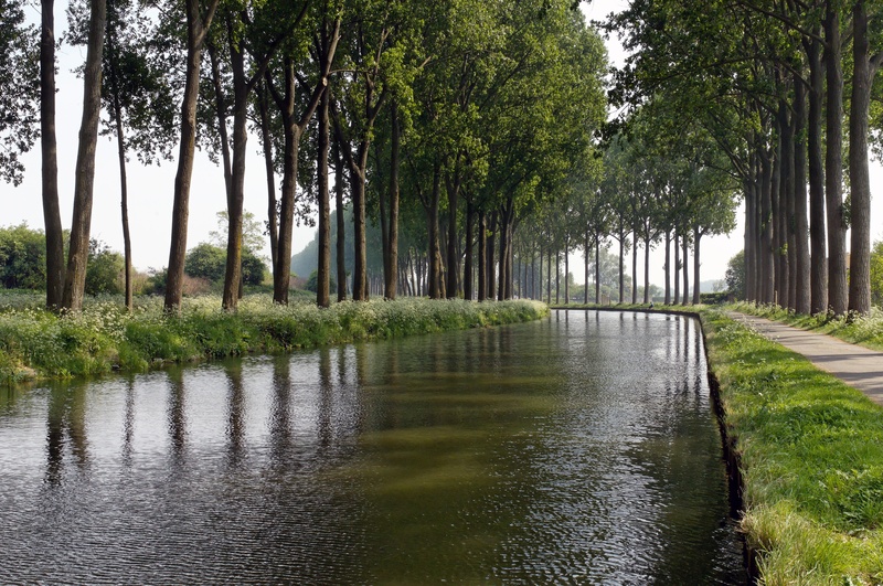
Going along the Espierres canal, you can immerse yourself in the past of the inland waterways in this lovely region with its small locks and drawbridges that will send your imagination sailing along with the lapping water. This canal, which fell into disuse in 1985, was listed as part of Walloon heritage in the year 2000. The pastoral, restful atmosphere in this magical place will make you want to slow down and enjoy the moment.
The route starts in Leers-Nord (Estaimpuis), at the Maison du Canal coffee shop, where a small car park awaits you.
When you reach Espierres-Helchin/Spiere-Helkijn, you join the left bank of the Scheldt and follow the river towards Warcoing and Pecq. Here you can’t help but notice that the peace and quiet of a preserved canal is at an end and the waterway traffic becomes heavier.
At the Warcoing sugar refinery you cross to the other bank over the suspension bridge. This time you follow the course of the river along the right bank towards Flanders.
Shortly after Escanaffles you will see in front of you the magnificent cycle-footbridge known as the Pont de chemin de fer over the old No 83 railway line which once linked Avelgem to Renaix/Ronse and has now been partly converted into a greenway. This is where you leave the water’s edge for good to join the Line 83 RAVeL. You enter the Pays des Collines nature reserve. You cross the rural commune of Mont-de-l’Enclus, where the landscapes attract many hikers. Your route comes to an end in the centre of the village of Russeignies.
Details
The route:
The route runs largely along the RAVeL of the Espierres Canal, the Scheldt and Line 83 in Wallonia. Occasionally it also goes along other quiet roads which are part of the Wallonie picarde (Western Hainaut) by bike nodal-points network, where you simply have to follow the signs all along the stage.
The stage starts in Wallonia, just after the French-Belgian border, at the Leers-Nord lock, rue du Canal in Leers-Nord (commune of Estaimpuis). Simply go alongside the Espierres Canal for about seven kilometres.
When you reach Espierres-Helchin/Spiere-Helkijn, you leave the Espierres Canal and join the Scheldt. You cross the N353 main road and take the ‘Oudenaardseweg’ path. You reach the left bank of the Scheldt and follow the course of the river.
At the Warcoing sugar refinery you cross to the other bank over the suspension bridge and follow the RAVeL along the right bank of the Scheldt. A rest area awaits you here. This time you follow the course of the river towards Flanders. Shortly after Escanaffles, at the cycle-footbridge over the old No 83 railway line, you leave the water’s edge and join the Line 83 RAVeL, which you then follow to the centre of Russeignies.
Surface:
Smooth - alternately asphalt and concrete.
Height difference:
Imperceptible incline, ascent of 56 metres.
Signs:
Full directional signs.
Connections:
- Path shared with the EuroVelo5 cycling route (EV5) as far as the bridge over the Espierres Canal at Espierres-Helchin/Spiere-Helkijn and with the W4 regional route as far as Warcoing.
- The route is also shared with the EuroVelo 5 cycling route (EV5) between the Line 83 footbridge over the Scheldt and Russeignies.
- Canalised Marque river and Roubaix Canal greenway (F).
Warnings
Useful info
Start:
Access by train:
• From Estaimbourg railway station, which lies about five kilometres to the south of the starting point, take the N510 towards Pecq for about 600 metres. Then take the first left towards Leers-Nord. Follow nodal points No 45, 36, 34, 32 and 30.
• As you leave Herseaux railway station, which lies about 6.5 kilometres to the north of the starting point, head towards the level crossing on the N512 (Chaussée d’Estaimpuis). Turn left and carry on for just over 300 metres, then take the 3rd right (to the right of the crossroads with traffic lights). Then follow nodal points No 29, 33, 34, 32 and 30.
Parking possible near the starting point.
Rest area:
In Warcoing, at NP No 48.
Guides/maps:
- RAVeL map of the Province of Hainaut published by the SPW. This map, called ‘More RAVeL, more pleasure’, can be ordered free of charge by clicking here.
- Maps of West and East Wallonie picarde (Western Hainaut) by bike: http://wapishop.be
Around the route by bike:
- Wallonie picarde (Western Hainaut) by bike: http://www.wapinature.be/-A-velo-.html
- Hainaut by bike – Hainaut Rando routes https://www.visithainaut.be/
- Canalised Marque river and Roubaix Canal greenway (F).
Stage map