Find my route
De Frameries à Hornu (Quaregnon) (stage 3)
On the Line 98C RAVeL

Family
")
8 km
The Line 98C RAVeL is brimming with life: people walking, young parents letting their children make their first somewhat clumsy attempts on wheels, pétanque players using the sites they have traced out, a few onlookers, enjoying a drink…
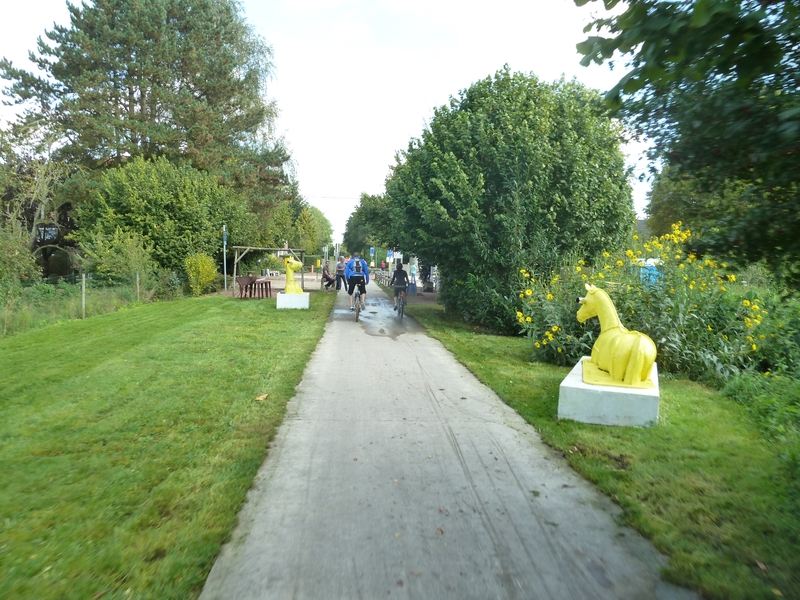
This old railway line, which once linked the various collieries, has found a new lease of life, becoming an area for walking and cycling at the heart of the Borinage. And thanks to the cultural non-profit association Blanc Murmure, it has now become a real artistic route between two leading museum centres, the PASS science and technology park and the Grand-Hornu industrial site.
As part of Mons 2015, when the city was the European Capital of Culture, the Blanc Murmure centre of expression and creativity brought life to the Line 98C RAVeL. This vast associative and artistic project was undertaken by 250 local residents (children, young people and adults) and resulted in the installation of 11 original works, including an enormous earthworm forming a rest area, amusing pictograms prompting questions, a Mario Bros screens game in the mine galleries, a ‘suitcase tree’ evoking immigration, coloured horses referring to the world of the collieries and more.
Details
The route:
The route follows its own safe path along the Line 98C RAVeL.
The trip starts in the village of Noirchain, through which runs the Bavay-Utrecht Roman road (or the chaussée Brunehaut), also known as the salt road.
From the industrial park and rue Montavaux, you follow the RAVeL, pass beneath the railway line and go back into this street again. You cross over, pass beneath a bridge and enter the PASS, the old mining site remarkably restored and converted into a scientific adventure park. You can cross the route de Mons over a bridge. You then go past the Mont Ostène slag heap, underneath the Axiale Boraine (N550) and back onto Line 98 just before Flénu railway station. Four hundred metres further on, you leave Line 98 and head to the Quartier de Monsville in Quaregnon. Be careful, you will then have to cross a busy road.
Having crossed a few roads, you reach the Grand-Hornu, a site devised and treated on a paternalistic and utopian basis by its owner, Henri De Gorge, a French industrialist and colliery owner, as a ‘model city’.
One of the modern-day buildings houses a real gem: the Musée des Arts Contemporains de la Fédération Wallonie-Bruxelles (MAC’s - museum of contemporary art of the Wallonia-Brussels Federation).
Surface:
Smooth (alternately asphalt and concrete).
Height difference:
Flat.
Signs:
Full directional signs are in place along the entire route.
Safety, precautions:
Take care when crossing roads.
Connections:
- In Flénu, connection with Line 98, the backbone of the RAVeL in this region of the Borinage.
Warnings
Useful info
Start:
Rue Montavaux, Frameries.
Coordinates Lambert 72 : X : 117895 m - Y : 121774 m
GPS coordinates: Latitude: 50°24'21.56'' N - Longitude: 3°55'01.57'' E
Finish:
Rue de la Justice, Hornu (Quaregnon).
Coordinates Lambert 72 : X : 112783 m - Y : 125181 m
GPS coordinates: Latitude: 50°26'10.74'' N - Longitude: 3°50'41.48'' E
Rest areas:
There are several rest areas.
Guides/maps:
- RAVeL map of the Province of Hainaut published by the SPW. This map, called ‘More RAVeL, more pleasure’, can be ordered free of charge by clicking here.
Around the route by bike:
- Hainaut by bike – Hainaut Rando routes.
Stage map