Find my route
De Angleur (Liège) à Hamoir(stage 1)
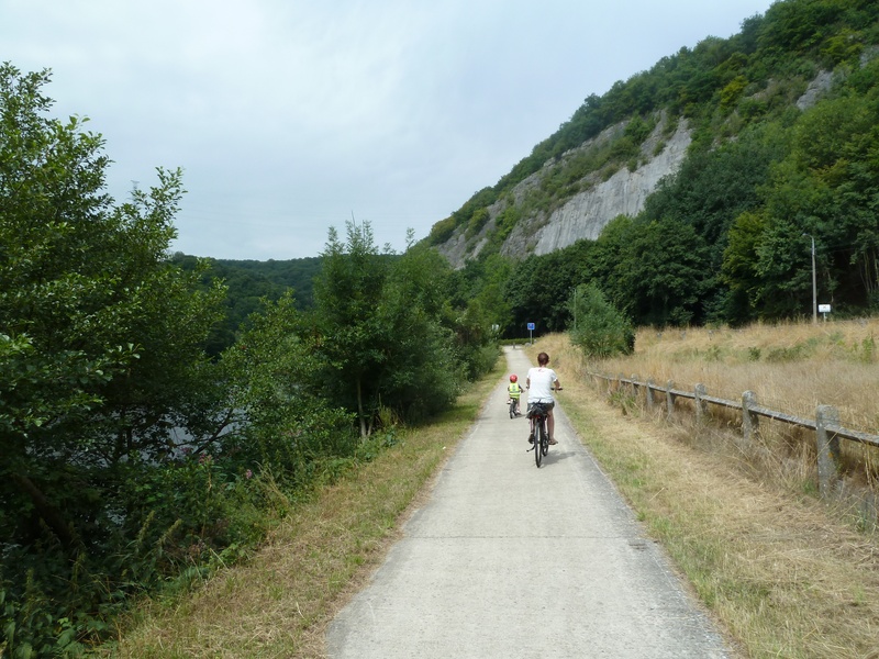
Sur le RAVeL de l'Ourthe

Family
")
39,5 km
This stage starts in Liège, at the foot of one of its many bridges, and leads into the Ourthe valley, whose beauty has been preserved. You can enjoy a breath of fresh air along this flat, safe rural path along the Ourthe RAVeL, which follows the curves of the river while enabling walkers to reach its local tourist sites quickly.
From the confluence with the Meuse (Fétinne bridge) to the end in Hamoir, this RAVeL takes walkers to the foot of rocky massifs (the Rochers-du-Bout-du-Monde, the Roche-aux-Faucons) or geological curiosities (the Tartines), to the heart of tourist cities (Tilff and Esneux) or past old quarries (La Gombe and Poulseur).
All the way along, this RAVeL flirts with the remains of the old Ourthe canal, a project that began in the early 19th century and was to link the Meuse to the Rhine via the eastern Ourthe, the Frayne, the Woltz, the Sûre and the Moselle.
Witnesses of human activity past and present, remains of the old Ourthe canal, locks, artistic events, architectural, geological and natural curiosities will delight dreamers and poets.
Details
The route:
This stage follows its own safe path on the Ourthe RAVeL.
Surface:
Smooth, alternately asphalt and concrete.
Height difference:
Flat or imperceptible incline.
Signs:
The entire stage is marked by specific ‘W7 – Ourthe RAVeL’ directional signs.
Warnings
Useful info
Start:
Quai du Condroz 27-29, 4031 Angleur (Liège), along the Ourthe river opposite the school of engineer HELMo Gramme, not far from the Fétinne bridge, Fragnée and the Belle-Île shopping centre. On the left bank of the Ourthe.
Coordinates Lambert 72: X: 236260 m - Y: 146122 m.
GPS coordinates : Latitude : 50°37'9.75" N - Longitude : 5°35'15.88" E.
Access by Train : Liège Guillemins SNCB railway station.
Finish:
Rue du Pont à Hamoir.
Coordonnées Lambert 72 : X : 232939 m - Y : 124519 m.
Coordonnées GPS : Latitude : 50°25'31.51" N - Longitude : 5°32'09.66" E.
Access by Train : Hamoir SNCB railway station.
Join stage 2:
Walkers and mountain bikers should follow the path along the edge of the Ourthe.
For cycling tourists, a connecting route follows stretches of regional roads, where the traffic is often fast, to the second stage to Bomal.
In Hamoir, take the N831 towards Verlaine-sur-Ourthe and Durbuy. Upon leaving Hamoir, the N831 has a cycle path. On the long, straight stretch, leave the N831 towards Verlaine-sur-Ourthe. Follow the road that leads along the edge of the Ourthe. You will come to a railway bridge over the Ourthe. The short stretch of the RAVeL begins a little further on, on the left bank of the Ourthe, between the village of Sy and the Domaine de Palogne tourist and leisure park.
When you reach the Domaine de Palogne, cross the Ourthe via the footbridge. Take the small road to the Logne fortress. At the castle, turn left into rue de Saint-Cergue. This takes you to the N86, which you follow on your right as far as Bomal. In Bomal, turn right on the N806. Just after crossing the bridge over the Ourthe, a ramp on the left leads to the RAVeL along the river and the start of the second stage.
Rest areas:
Numerous along the Ourthe RAVeL, in particular in Tilff, Mery and Esneux. Some of them have playgrounds.
Guides/maps:
- RAVeL map of the Province of Liège published by the SPW. This map, called ‘More RAVeL, more pleasure’; can be ordered free of charge by clicking here.
Stage map