Find my route
De Péruwelz à Mons (stage 3)
On the Nimy-Blaton-Péronnes canal RAVeL

Family
")
30 km
Starting from Péruwelz in the direction of Mons means heading towards a crossroads for riverboats: Blaton. This place is famous for its canals. Here all the canal traffic can choose to go to France, Flanders, Hainaut or even further afield at a single point.
Throughout this route you will be travelling along the Nimy-Blaton-Péronnes canal RAVeL, sometimes on the left bank, sometimes on the right. In particular, you go through Bernissart, a commune characterised by the marshes of Harchies and iguanodons lying at the heart of a major riverboat hub.
When you arrive in Blaton, you discover the floodgate that divides a 39 km millstream into two shorter sections in order to cope with any eventuality or problem that may arise without the canal being affected.
You then head towards the Borinage and you have another fifteen kilometres to cover to reach the Grand Large in Mons, the end of this stage. The city of Mons, capital of the province of Hainaut and cultural capital of Europe in 2015, is a land of the ducasse or fair, traditions and good nature. Here you will find a collegiate church, a belfry, a listed city hall, a fair classed as a masterpiece of intangible cultural heritage by UNESCO, but also modernity, in the form of Calatrava railway station which is under construction, the Conference Centre (MICX) by architect Libeskind, the Manège theatre, ArtSonic, and more. Van Gogh, Verlaine and Hugo came here. Roland de Lassus, Du Broeucq, leading artists of the High Renaissance were born here. During the year of culture, two million visitors followed in their footsteps.
Details
The route:
You remain on the safe path of the Nimy-Blaton-Péronnes canal RAVeL throughout this stage.
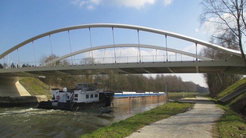
Having gone under the superb Harchies bridge, supported by two sloping metallic arcs, you take the parallel street on your right (rue de l’Industrie) which brings you back to this bridge. You cross the canal and take the Chemin du Bois to the right to reach other bank (the right one, this time). You then continue on the RAVeL along the bank towards Mons.
You cross through Saint-Ghislain, Baudour and Ghlin. Leaving the Ghlin Nord inner harbour, to change bank again we advise you to take rue des Ayettes towards Mons and Ghlin on your left. Go over the Belvédère suspension bridge. After the bridge, turn right immediately to reach the left bank of the canal. You continue along the RAVeL towards Mons. (Another solution, which is far less practical for families and cyclists with luggage, is to take the footbridge before the Grand Large, which is only accessible via steps with a channel for bikes).
When you reach the Grand Large, go past it and turn left into avenue de la Sapinette, which is the end of this stage.
We advise you to extend your trip along the right bank of the Canal du Centre and avenue des Bassins as far as the Conference Centre (MICX). You then have to cross the railway tracks to reach the centre of Mons.
Surface:
Smooth (alternately asphalt and concrete).
Height difference:
Flat or imperceptible incline.
Signs:
Full directional signs with W4 identification panels are in place.
Safety, precautions:
Watch out for the alternating separate paths and loading quays near industrial zones.
Connections:
- In Blaton, connection with the W1 regional route, either towards Ath or towards Quiévrain.
- Again in Blaton, connection with the RAVeL of the Blaton-Ath canal and Line 78A.
Warnings
Useful info
Start:
Crossroads between Notre-Dame bridge and the Quai du Marché au Poisson in Tournai.
Coordinates Lambert 72 : X : 94949 m - Y : 134559 m
GPS coordinates: Latitude: 50°31'09.20'' N - Longitude: 3°35'32.82'' E
Access by train: Péruwelz railway station. From the station, go along rue du Ponsart and rue des Basses Watines towards the canal. When you reach the canal, turn right towards Blaton.
Rest area:
Just before Blaton.
Car parks along the route:
- Péronnes (lez-Antoing), rue du Rivage: 20 places, including for people with reduced mobility.
- Péronnes (lez-Antoing), rue du Large: 7 places, including for people with reduced mobility.
- Roucourt, rue de la Guerison: uncertain number of places, accessible for people with reduced mobility.
- Péruwelz, Quai de Paray-Vieille-Poste: 5 places, including for people with reduced mobility.
- Bernissart, rue des Iguanodons: 5 places.
- Stambruges, Chemin du Bois: 5 places.
- Hautrage, Route de Wallonie: 10 places.
Guides/maps:
- RAVeL map of the Province of Hainaut published by the SPW. This map, called ‘More RAVeL, more pleasure’, can be ordered free of charge by clicking here.
- Map of East of Wallonie picarde (Western Hainaut) by bike: wapishop.be.
Around the route by bike:
- Hainaut by bike – Hainaut Rando routes: www.hainauttourisme.be/loisirs-et-activites/itineraires-thematiques/.
Stage map