Find my route
De Grammont/Geraardsbergen à Beloeil (stage 1)
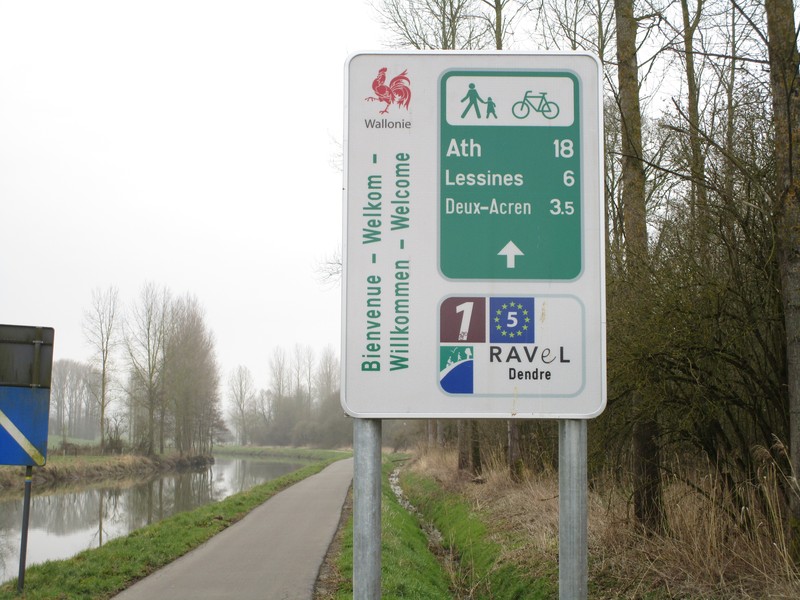
On the RAVeL of the Dendre and the Blaton-Ath canal

Family
")
33 km
Riding from Grammont/Geraardsbergen to Beloeil, you go from a steep, paved street and a major cycling centre to gentle landscapes with barely an incline, where music can be heard at the foot of a castle in summer. Why not come and enjoy a gentle contrast. Although… when the ducasse or fair comes to Ath, the quiet atmosphere can start seething! In fact, the RAVeLs of the Dendre and of the Blaton-Ath canal alone can explain.
Along the Dendre river and the Ath-Blaton canal, which have a gauge of 300 tonnes and are therefore used mainly for pleasure cruising, your ride is far more pastoral than elsewhere. Be sure to visit the Notre-Dame à la Rose hospital in Lessines, which bears rare witness to the development of medicine, surgery and pharmacy from the Middle Ages to the present day. Having admired its remarkable architecture and its gardens of medicinal plants, you can set off for Ath. Its outstanding folklore and rich past make this town essential visiting. You’ll not soon forget Gouyasse (Goliath), the processional giant of the ducasse, Mastelles tart (with biscuit and almonds) and the friendly welcome.
Your stage ends in Beloeil, where the castle of the Princes de Ligne and its gardens will leave a lasting memory.
Details
The route:
The town of Grammont/Geraardsbergen at the heart of the Flemish Ardennes, famous among cyclists for its muur, a steep, cobblestone street, will be our starting point. So go to nodal point (NP) No 81 (at the ‘Grotestraatbrug’) of the cycling route network in the Province of East Flanders. From there, you go along the greenway, then the Dendre RAVeL to Lessines and NP 83 of the nodal-points network of Wallonie picarde (Western Hainaut).
When you reach Ath, you follow the Blaton-Ath canal RAVeL to Beloeil.
Surface:
Smooth (alternately asphalt and concrete).
Height difference:
Flat or imperceptible incline.
Signs:
Full directional signs with W1 identification panels are in place.
Warnings
Useful info
Start:
Pont de la Grand'Rue, Grotestraatbrug, in Grammont/Geraardsbergen, nodal point No 81 of the East Flanders network.
Coordinates Lambert 72 : X : 115505 m - Y : 162462 m
GPS coordinates: Latitude: 50°46'17.88'' N - Longitude: 3°52'47.00'' E
Access by train: From Grammont/Geraardsbergen railway station, join the nodal-point network (knooppunten) of the Province of East Flanders on Grand’Rue (Grotestraat) and follow nodal points No 81, 83, 28 (first nodal point in Wallonie picarde (Western Hainaut) on the Dendre RAVeL), 32, etc.
Access by car: Pay car park at the start.
Other car parks along the route:
• Deux-Acren, stadium car park.
• Lessines, rue des Moulins (four places).
Rest areas:
• Along the Dendre RAVeL between Papignies and Rebaix, near NP 39.
• In the centre and as you leave Ath.
Guides/maps:
- RAVeL map of the Province of Hainaut published by the SPW. This map, called ‘More RAVeL, more pleasure’, can be ordered free of charge by clicking here.
- Map of East Wallonie picarde (Western Hainaut) by bike: wapishop.be.
Around the route by bike:
- Wallonie picarde (Western Hainaut) by bike: www.wapinature.be/-A-velo-.html.
- Hainaut by bike – Hainaut Rando routes: www.visithainaut.be/fr/content/les-randonnées-à-vélo.
Stage map